There are a lot go reasons why one should experience trekking and this trek especially – the forests, the birds, the fabulous mountain views, the experience of living in a tent at 0 Celcius, Overall adventure, etc. For three days, you trek through dense rhododendron, maple and oak forests. On the fourth day, you trek with the most astounding views of the Garhwal peaks. Atop the peak, on a clear day, you can get a 360 degree view of peaks like Nanda Devi, Chaukhambha and Trishul.
Another highlight of the trek is the chance to climb up to the world’s highest Shiva (also known as ‘Mahadeva’, one of the principal deities of Hinduism) Temple. Tungnath is a thousand-year-old temple and is one of the five Panch Kedar, the holiest of Shiva Temples. The sunrise (we managed to capture 2 time lapses do check it out towards the end!) from the Chandrashila summit wraps up the trek with strong emotions and memories to take back home.
Day 1: Getting to the base camp – Sari
- Altitude: 6,601 feet
On the first day of the trek, the journey began with a drive from Haridwar to Sari village. The journey was picturesque the confluence of Rivers Alakananda and Bhagirathi to form River Ganga. The entire journey traverses the mountain side, with the river flowing below you.
Quick tip: Pick the window seat on the right to enjoy the views!


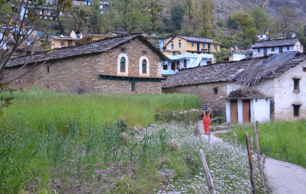
We reached Sari by 6 pm. Sari is a small village with around 100 houses. If you reach Sari when the sun is still out, go down to the village and walk around. There is a small school amongst the fields. This school was built in 1947 and is the only school at Sari. The views around the village are gorgeous!
Day 2: Sari to Deoriatal
- Altitude: 6,601 feet to 7,841 feet
- Distance: 3 km
- Time taken: 1 hour
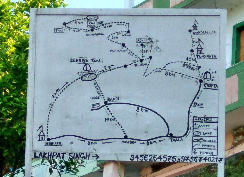
The adventure starts from Sari. There is a sign-board indicating the trek route to Deoriatal in the heart of the small market in Sari. The sign board says Devariya Tal, which is an alternative name for the lake. It’s called so because it’s believed that devis (Goddesses) once came to the lake to take a dip.
A well-defined rocky trail is laid here. This trail begins with a gradual climb up the mountain. After approximately 15 minutes, we came across village houses and an old local temple.

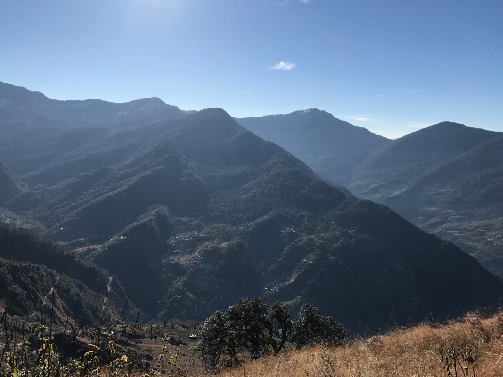
Ten minutes into the hike, the trail starts to become steeper and steeper. The forests have been cleared here, so one will get a good view all around. At the valley-facing end, one can see the summit of Chandrashila and below it, the holy Tungnath temple. The trail is well-defined all the way to Deoriatal. After a steady uphill trek for about 20-30 minutes, we reached the first view-point. The Forest Department has constructed a hawa ghar for the travellers here. This spot is ideally located to relax and feast your eyes with a grand view of the mountains and the valley.

After a steady hike of ten minutes, we reached the second view-point. Now, at 7,434 feet, Sari was no longer visible.
With only a kilometre left, we found ourselves at the backside of the mountain and got a view of the Ukhimath side of the valley, though only for a while. Another 20 minutes later, we found a dhaba.
Deoriatal is just two minutes away from here. After a very short downhill trek, the surroundings opened up to a grand view of Deoriatal, with Mt. Chaukhambha looming in the background.
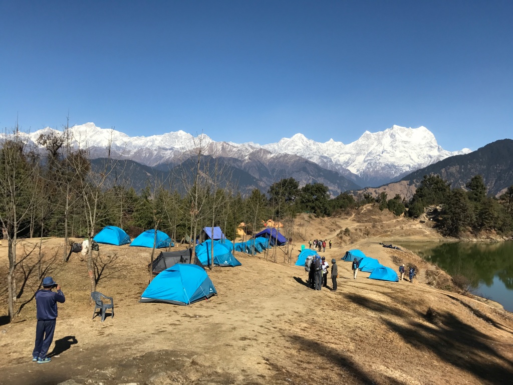
There’s nothing much to do here as you reach, you can go around the campsite and explore the trails around. The forests around here are lovely. An enthusiast can be able to see and hear several rare Himalayan birds. There’s a watch tower close to the lake that gives you grand views of the surrounding mountains.
The beauty of the view generally intensifies in the morning, when the clouds have cleared to offer unreal views of the hills. No camera can ever do justice to these scenes.
Although getting ready and packing up at 6am at Zero Degree Celsius can be a big and time consuming task. We had a record of not being on time a single day of our trek. Wrapping the sleeping bags can be tricky too if it’s your first time and one must come to terms with using the portable toilet. Personally, washing dishes or hands in that cold was the most daunting task. Since the temperature falls below zero degrees by 8pm, with winds, the water tends to freeze or is on the verge of it.

Day 3: Deoriatal to Rohini Bughyal
- Altitude: 7,841 feet to 8,790 feet
- Distance: 8 km
- Time taken: 6 hours
There are no water sources during this trek. The next water source is a small stream towards the end of the trek and otherwise directly at the campsite at Rohini Bugyal. We always carried atleast 2-1 Litre Bottles with us. Carrying a bladder is a good idea, however it’s hard to carry when you already have a trekking bag on your shoulder.
Full of rhododendron and maple trees, this trail was a beautiful one. Every now and then, the Kedar Dome and Chaukhamba peaks peek at you through the trees and don’t stop being mesmerising.
There is a small clearing as we exited the forest. In front of us, the Chandrashila peak was visible.
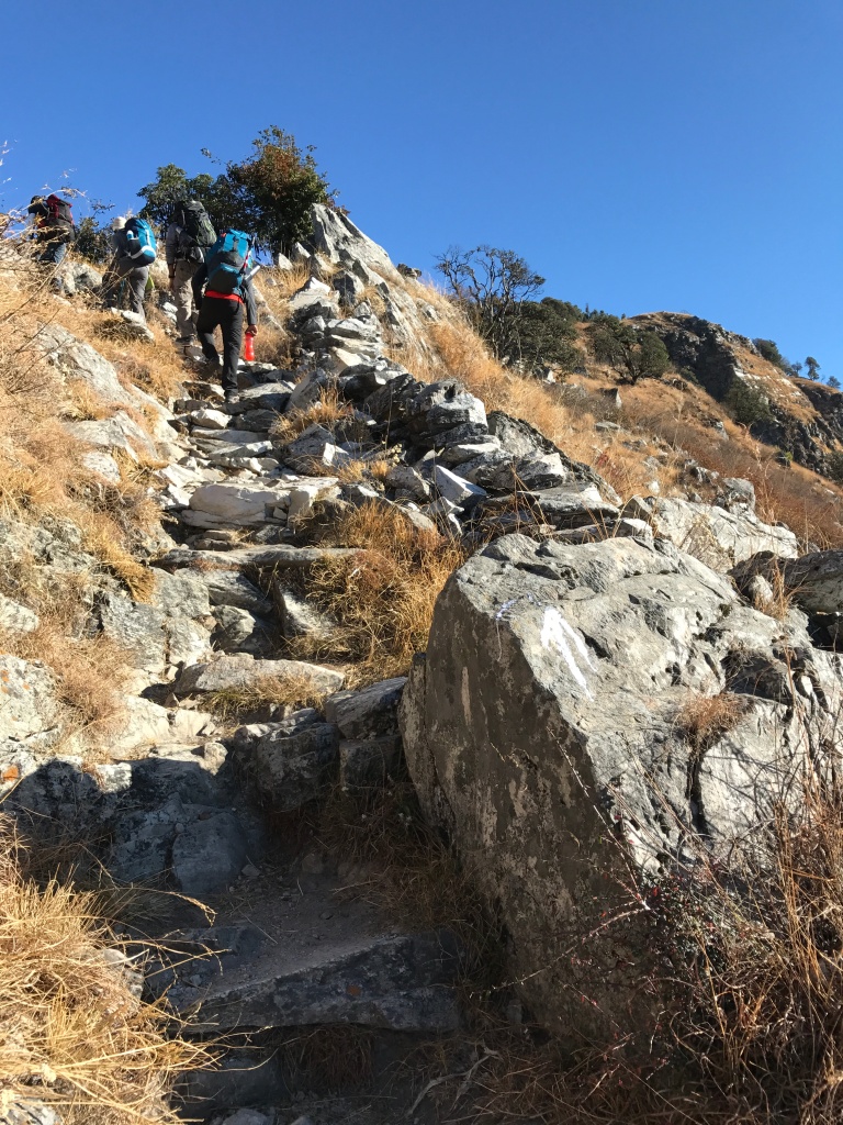
Taking the ascending trail ahead of us as we got a much better view of both sides of the valley. The ascent is steep, and one can hire a porter in case picking up their backpack becomes too difficult. However, this has to be decided and told to the trek leader the previous day at the base camp. The fee is about Rs.350/day/bag.
After 15 minutes of climbing the ridge, there is a hill-top with a flag post. This is Jhandi Dhar. In the month of March and April, the trail is blazing with red and pink flowers of rhododendron.
The forest continues to thicken throughout the trek. We were mistaken to have thought the forests until now were dense. In some areas, we also found snow across the trail. It is important to see whether that snow is fresh or frozen. Fresh snow is never slippery, frozen snow is! One should always watch every step around snow.

From here, there is a steep descent. The descent is sharp, but pleasant. Further, the trail took an eventful turn as we entered the forest ridge. The flora of the region was stupendous. Every now and then, we came across small shrines with bright yellow flags tied to them. These were all made by tourists and localites. One could use these as landmarks to ensure they’re on the right trail. One should keep an eye out for wild animals here, although they don’t usually show up around groups, especially during the day!
After 20 minutes of gradual ascent, there’s a walk on level land, the trail opens to a small pasture land. We exited the forest even as the view of Chandrashila peak greeted us up front. Just before us, there was a second forest ridge that needed to be traversed. The trail ascended sharply as we re-entered the forest once. This part of the forest had some of the oldest oak, maple and rhododendron trees of the Kedarnath Sanctuary.
By now, we had already trekked approximately 5 km. There were three trails branching out from here. From here, we could see the Kala Parvat, which is a peak located on the right of Chandrashila peak. Below Kala Parvat is a small glacial lake, called Bisuri Tal. As the legend has it, the Pandavas hid their weapons here.
The trail from here was a leisurely walk ahead for about 30 minutes as we passed a small rivulet. The stream was the only source of water and it is advisable to fill your bottles here. Rohini Bugyal is about a 3 minute walk from here.

Day 4: Rohini Bughyal to Chopta
- Altitude: 8790 feet to 9100 feet
- Distance: 6 km
- Time taken: 5 hours
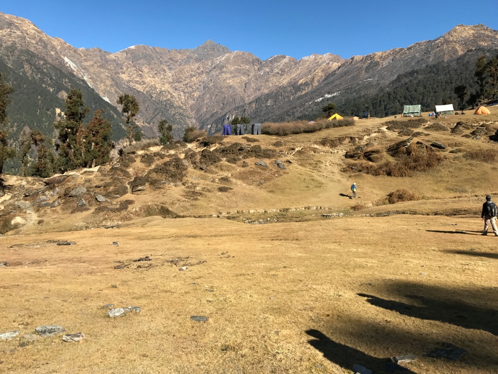
Rohini Bughyal is a small meadow surrounded by a beautiful rhododendron forest and view of the Kedar dome and the Kala Parvat peaks. The sunset view from here is incomparable!
This was a short and easy trek that involved traversing the ridge of Rohini Bughyal to enter the meadows of Bhrujgali. From the campsite of Rohini Bughyal, one can observe a tall rhododendron tree, which is just a five minute walk from the camp site.
We entered the forest of upper Rohini Bugyal and reconnected with the trail to Chopta. The trail that ascended gradually all the way to the top of the forested ridge. It took us 30 minutes to reach the ridge top, which was covered in dense forest cover. The locals call this spot as Tikidi Khal.
From here, there are two trails.

We took the second trail and descended 500 feet to reach the stream crossing. It took us 20-30 minutes to reach the stream. It’s a good idea to refill your water bottles here. There is a small bridge that needs to be crossed. We were lucky to get a lot of snow here, which meant snow fights for an hour.
From here, we took the trail that now ascended gradually with a series of three scissor bends. As we climbed up, the view of the valley got better and better. Around 20 minutes of steady climb took us to a small meadow. There were a series of shepherd huts here made of stones. In summer, one could find locals occupying the huts with their livestock.
As we entered the meadow, a diversion towards the right and around 20 minutes of descent through a jungle trail,we came upon a road ahead. A kilometre walk from here to reach the Chopta campsite.
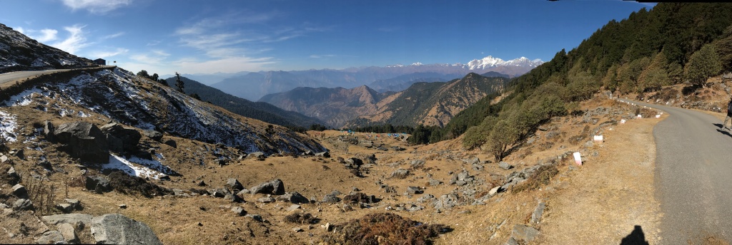


Day 5: Chopta to Chandrashila Peak via Tungnath and back to Chopta
- Altitude: 8790 feet to 12,083 feet
- Distance: 8 km trek
- Time taken: 4 hours
We were ready to leave by 3:30 am, so that we could treat ourselves to a sunrise view from the Tungnath and Chandrashila peak. The trek from Chopta to Tungnath is accessible via a cemented pilgrim trail. It ascends sharply via a series of scissor bends. The walk is pleasant, but is a very steep climb. The trek up to Tungnath temple is approximately 2 km.
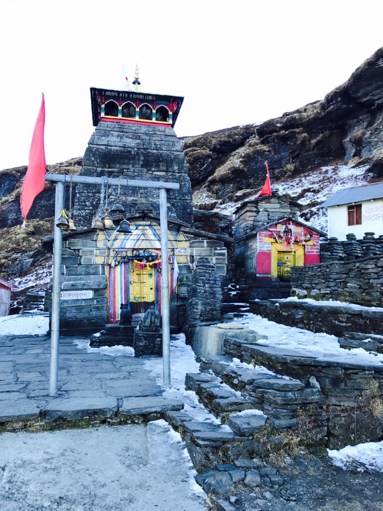
Chandrashila peak is 1.5 km above the temple . The route to Chandrashila peak is through the backside of the temple. During winter, this trail is completely buried in snow. Those planning to do a winter trek here by themselves, are strongly advised to carry crampons/micro-spikes and an ice-axe. We too went in December, however there was only one occasion of light snowfall and hence no extra equipment was necessary.
The climb from Tungnath to Chandrashila was an ascent of 600 feet and was a very steep climb. After negotiating a series of switchbacks, we reached the upper base of Chandrashila Peak. From here, the summit of Chandrashila is visible. The climb up to the summit takes 30-45 minutes.


Once at the top of the peak, one can get a 360 degree view of the mountains of Garhwal and Kumaon. Walk past a tiny temple and see some great mountains of Uttarakhand, like Nanda Devi and Chaukhamba and more. The sunrise view from this spot is the best I’ve ever seen.

The trek back to Chopta is via the same route taken to reach here. It takes 20-30 minutes to reach Tungnath and another 60 minutes to reach Chopta from Tungnath.
We chose to head down to Chopta on the same day.
Day 6: Depart for Haridwar
We Boarded our jeeps from Chopta for a drive back to Haridwar. We reached Haridwar between 6 – 7 PM. It was about a 10 hour car ride, so one must leave accordingly.
It is advised that you keep a buffer day because the weather is unpredictable in the mountains. Rest at Haridwar for the night. You can explore Haridwar the next day and take the Mussoorie Express or Nanda Devi Express to Delhi in the evening.
Note : For more updates and photos, please follow us on Facebook, Instagram, Twitterand YouTube.

Looks so amazing! But… did you say “stay in a tent at ZERO degrees Celsius”?! I’m struggling with 6 degrees in an apartment! 🥶
LikeLiked by 6 people
Yes, zero degrees!
Although we had those insulated sleeping bags!
LikeLiked by 1 person
i have no words to explain my feeling
LikeLiked by 5 people
I hope they’re positive feelings!
LikeLiked by 2 people
off couse they are positive
LikeLiked by 2 people
I’m really glad to hear that 😇
LikeLiked by 2 people
Beautiful presetation. Thank you.
LikeLiked by 5 people
I’m glad you like it 🙂
LikeLiked by 1 person
Outstanding post. I love the photos and details.
LikeLiked by 5 people
Thank you so much 🙂
LikeLiked by 2 people
Sounds like a wonderful experience! ~WB
LikeLiked by 6 people
It really was!
LikeLiked by 2 people
wow! quite a rigourous and fun trip!
LikeLiked by 4 people
It really was fun!
LikeLike
What an incredible adventure!
LikeLiked by 4 people
Quite an adventure. Many thanx for sharing.
Art
LikeLiked by 4 people
I am glad you liked it!
LikeLike
Fascinating journey! Your words and images emphasize both the beauty of the trek as well as the challenges. How much the elevation affect the difficulty of the trip?
LikeLiked by 6 people
It did play a huge role, more so in the begging of the trip when we were still getting acclamtized.
Our guides measured our blood pressure and oxygen levels on a daily basis to ensure safety and the elevation directly affected it!
LikeLike
fabulous report. The trek looks to be an amazing experience in such beautiful environment.
LikeLiked by 4 people
Yes, it was beautiful and a great experience!
LikeLike
What an experience it could have been! Wonderful!
LikeLiked by 4 people
It was really really beautiful!
LikeLike
Wonderful to read this.
LikeLiked by 3 people
I’m glad you like it!
LikeLike
Çok güzel çok
LikeLiked by 3 people
The views here look stunning💜
LikeLiked by 4 people
Phenomenal pictures. Truly enjoyed your narrative… detailed and informative, loved the videos too.
LikeLiked by 5 people
Thank you so much, I’m glad you like it 🙂
LikeLiked by 1 person
Incredible photos. Thanks for posting!
LikeLiked by 4 people
Thank you, I’m glad you like it 🙂
LikeLike
Beautiful place!
LikeLiked by 4 people
It really was!!
LikeLike
Thanks for documenting the whole experience. It is real challenging and marvellous. It is also nice that you have shared with other people.
LikeLiked by 4 people
Thank you 😄
LikeLike
Amazing post! Thank you for stopping by and liking my blog!
LikeLiked by 3 people
This is amazing!
LikeLiked by 3 people
Thank you 🙂
LikeLike
Wow this is awesome!
LikeLiked by 1 person
Thank you 🙂
LikeLiked by 1 person
sounds like must do trek.
can we do it solo and without any guide??
LikeLiked by 2 people
If you’re a veteran trekker, you could (but it’s difficult since it’s a 3 day trek minimum). More so, I’d recommend against it for safety reasons!
LikeLiked by 1 person
Thank you for your advice. Will try this trek soon
LikeLiked by 1 person
How does one find guides for trekking adventures like this one?
LikeLiked by 1 person
If you check the india hikes website, they have treks going on all through the year.
They have a team set up at each trek/campsite and conduct treks accordingly!
LikeLiked by 1 person
Wow! Chandrashila is really a very breathtaking and beautiful place and I have really fallen in love with the beauty of this place. The trekking experience also looks very adventurous. I will definitely like to visit this place with my family and friends. I will definitely visit this place and I will also share this article as much as possible. Thank you.
LikeLike
after this article my next trek is going to be chandrshila.
Is this a self trek or guide is compulsory ?
LikeLiked by 1 person
A guide is not compulsory. But it’s convenient, because India Hikes has set up their own camp site and everything. So you need not carry your own tents and sleeping bags or worry about having to cook food. Plus trekking with a group in the mountains is much safer 🙂
LikeLiked by 1 person
Thank you for your advice
LikeLiked by 1 person
No problem!
I’m glad I could be of some help 🙂
LikeLike